IITM Logo

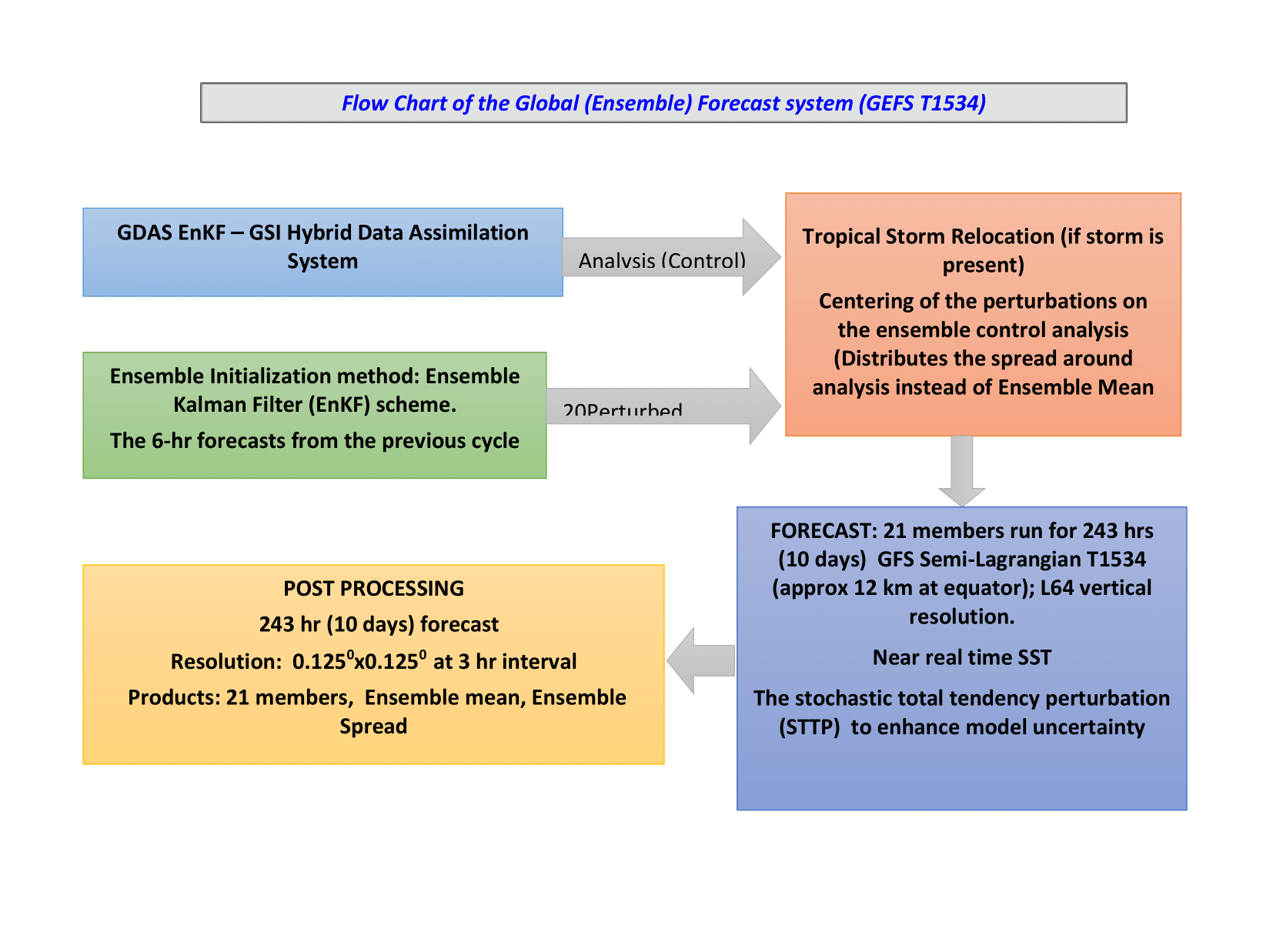
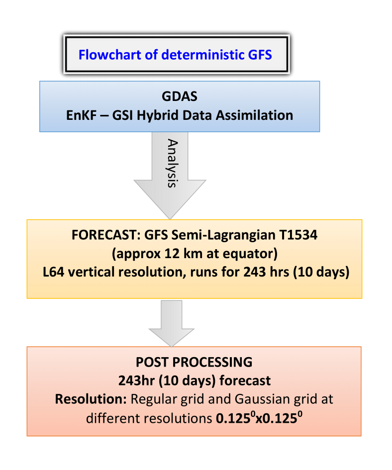
Short And Medium Range Prediction System

Indian Institute Of Tropical Meteorology, Pune
भारतीय उष्णदेशीय मौसम विज्ञान संस्थान, पुणे
bharat Logo

Background

The launch of the National Monsoon Mission (NMM) by the Ministry of Earth Sciences (MoES) in 2012 (Rao et al. 2019), and the decision by the Indian Institute of Tropical Meteorology (ESSO-IITM) to use the NCEP GFS/CFS (Saha et al., 2010; 2014) as a common platform for weather and climate prediction led to the development of dynamical modeling systems for short to medium range (1-10 days), extended-range (2-4 weeks), seasonal forecasts and climate projections. As part of this initiative, all research is conducted on the operational modeling framework based on GFS/CFS, and each modeling system was transferred to ESSO-IMD for operational use.

Short and Medium Range Prediction System Milestones

  • June 2016: Implemented deterministic NCEP Global Forecast System (GFS T1534, ~12 km) and ensemble prediction system (GEFS T574, ~ 27 km, 20 members) at IITM.
  • June 2018: Then Ensemble Prediction system was upgraded to T1534, and handed over to IMD for operational prediction.
  • July 2020: GFS and GEFS T1534 Forecast data made available for TIGGE
  • June 2022: Bharat Forecast System (~ 6km) implemented and run in experimental mode at IITM since June 2022. The model is operationalized since May 2025.
  • Various diagnostic products like strike probability for tropical cyclone, block level rainfall probability forecast, thunderstorm indices, percentile-based forecast for extreme weather events, Extreme forecast index (EFI), River basin forecast etc. are generated regularly to support the operational center (IMD).

GFS/GEFS (T1534) Model Physics for the operational set up

Convection
  • Scale- & Aerosol-aware mass-flux shallow convective scheme
  • Scale- Aerosol-aware mass-flux deep convective scheme
Microphysics Zhao-Carr-Moorthi microphysics scheme for Grid-scale Condensation, Evaporation and Precipitation
Gravity Wave Drag Orographic gravity wave drag, mountain-drag and stationary convective gravity wave drag
PBL New PBL Hybrid Eddy-diffusivity Mass-flux Scheme (Estimate Subgrid-scale vertical turbulent mixing in the PBL and above; mass-flux approach to calculate the countergradient diffusion terms)
Radiation LW and SW radiation parameterizations are optimized and modified (AER) by NCEP and uses unevenly distributed 140 g-points (quadrature) in 16-bands and 112 g-points in 14-spectral bands respectively. To represent statistically the unresolved subgrid cloud variability Monte Carlo Independent Column Approximation (McICA) is used. Cloud fraction for radiation is computed diagnostically from prognostic cloud condensate
Surface Land use land cover data (LULC) from National Remote Sensing Centre (NRSC)

About GFS-TCo 1534 version

As the GFS/GEFS T1534 modelling system is based on linear Gaussian grid with triangular truncation in the spectral domain, many challenges are being faced particularly in scaling the model in High Performance Computing (HPC) systems, the I/O issue, artificial damping of diffusion, even though the semi-lagrangian dynamical core allows larger time step to make the forecast run faster. To get rid of the above mentioned issues related to dynamical core of a high resolution model, a Spectral Cubic Octahedral (TCo) framework was implemented in the GFS. This new version was verified for the prediction of monsoon rainfall, tropical cyclones and extreme events that occurred during 2022-2024 (Phani et al. 2025). This new version, shows promising skill in predicting the rainfall in general and also in predicting heavy rain events. It also shows remarkable improvement in the track prediction of tropical cyclone forecasts.

Copyright © 2025 Indian Institute Of Tropical Meteorology (IITM), Pune, Maharashtra - 411008, INDIA.

All Rights Reserved | Designed & Developed by Mrs. Supriyarani Mandal (SMRPS team)