


Model GEFS - WRF Description
Thunderstorm Indices (LPI, Layrh, SCP) obtained from IMD-WRF (3km) Hourly outputs:
-
1. Lightning Potential Index (J/Kg)
Lightning Potential Index (LPI) is a measure of the potential for charge generation and separation that leads to lightning flashes in convective Thunderstorms. The basic formulation is as follows [Lynn and Yair 2008; Yair et al. 2010]:
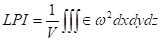 (1)
(1)Here, V is the volume of air in the layer between 0oC and -20oC, ω is the vertical wind component (m s-1), and is the function of cloud hydrometeors like qs, qi and qg are the model-computed mass mixing ratios for snow, cloud ice, and graupel respectively (in kg kg-1).
 is a dimensionless number that has a value between 0 and 1 and is defined by [Lynn and Yair 2008] as
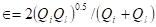 (2)
(2)Ql is the total liquid water mass mixing ratio (kg kg-1) and Qi is the ice fractional mixing ratio (kg kg-1) defined by [Lynn and Yair 2008] as
 (3)
(3)In essence,
is a scaling factor for the cloud updraft and attains a maximum value when the mixing ratios of supercooled liquid water and of the combined ice species (the total of cloud ice, graupel, and snow) are equal. Calculation of the LPI from the cloud-resolving atmospheric model output fields can provide maps of the microphysics based potential for electrical activity and lightning flashes.
Here, LPI has been calculated using IMD-WRF (3km) hourly model output. 24 Hour accumulated LPI has been generated by adding hourly LPI values. The threat of LPI has been categorized in Low, Moderate and High. LOW: LPI < 0.001 and >0.0005; Moderate: LPI :< 0.01 and > 0.001; Threat Level: High: LPI > 0.01.
-
2. SuperCell Composite Parameter (SCP):
It is defined by Carbin et al 2016 as:
 (4)
(4)CAPE is 0-180 hPa layer most unstable Convective Availabel Potential Energy in J/Kg
SRH is 0-3km Storm Relative Helicity in m2/s2
BWD is Bulk Wind Shear between 0-30hPa above ground layer and 500hPa
SCP > 1 indicated that the environment is conducive for thunderstorm formation.
The Threat Level of SCP has been categorized in Low, Moderate and High. LOW: 3 < SCP < 5; Moderate: 5 < SCP < 7; High: SCP > 7. -
3. Layer Relative Humidity (LAYRH):
Layer Relative Humidity is defined by Rajeevan et al 2012 as layer mean relative humidity from 1000hPa to 100hPa. The threat level of Layrh has been categorized in Low, Moderate and High. LOW: 20 < LAYRH < 40; Moderate: 40 < LAYRH < 60; High : LAYRH > 60